UCSB Beach - Oblique Aerial View
 |
|
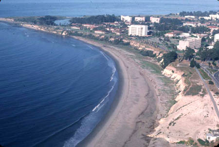
UCSB beach, 28 May 1978. Oblique aerial view toward southwest and UCSB campus of wide sandy beach. Tide height is unknown. Sand is transported from right to left along coast in background, thence around Campus Point in upper left corner, thence along beach from upper left to center to lower center. Lower two-thirds of seacliff consists of silty diatomaceous shale of Sisquoc Formation (Dibblee, 1987). Upper one-third is Quaternary terrace that is fossiliferous marine silt and sand in its lower part, and mostly aeolian sand and silt in its upper part. Unvegetated area in lower right corner is indurated Sisquoc Formation. The sand supply derives primarily from creeks that transport sand from coastal mountains west to Pt. Conception (Pollard, 1979). Less than 1% of the sand comes from erosion of the seacliffs (Runyon & Griggs, 2003). Dibblee, T. W., Jr., 1987. Geologic Map of the Goleta Quadrangle, Santa Barbara County, California. Dibblee Foundation Map #DF-07, scale 1:24,000. Pollard, D. D., 1979. The Source and Distribution of Beach Sediment, Santa Barbara County, California. PhD Dissertation, University of California, Santa Barbara. Runyon, K., and G.B. Griggs, 2003. The effects of armoring seacliffs on the natural sand supply to the beaches of California. Journal of Coastal Research 19(2), 336-347. |