Isla Vista Beach Cliff Erosion
 |
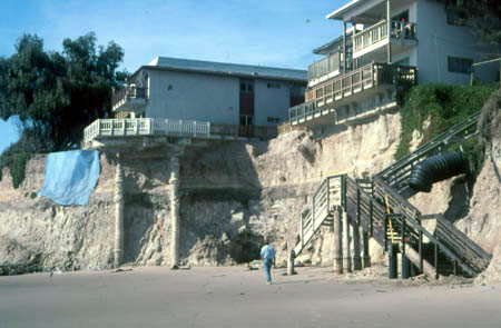
| Eroded beach cliff, Isla Vista, 4 December 1999. The rock beneath the dark gray layer is diatomaceous siltstone assigned to the Sisquoc Formation (Dibblee, 1987). The gray layer is marine silty sandstone and claystone. Nearly all of the rock above the dark gray layer is unlithified aeolian sand which, when eroded, contributes a small fraction of the sand needed for UCSB Beach. Foundation pilings beneath the house on the left were allegedly constructed "years after" the house was built as an emergency measure for a structure at risk. Their exposure today is an indication of the amount of cliff retreat since they were constructed. The blue tarp is intended to retard erosion of more cliff beneath the house. ©AGS1999. |
 |
|
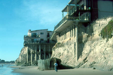
Eroded beach cliff, Isla Vista, 4 December 1999. The rock beneath the dark gray layer is diatomaceous siltstone assigned to the Sisquoc Formation (Dibblee, 1987). The gray layer is marine silty sandstone and claystone. Nearly all of the rock above the dark gray layer is unlithified aeolian sand which, when eroded, contributes a small fraction of the sand needed for UCSB Beach. The concrete pilings beneath the houses were allegedly constructed many years after the houses were built, but wholly within rock, as an emergency measure for structures at risk. The wall behind the man was built before 1980 and is intended to retard wave erosion. It consists of wooden pilings set in concrete and backfilled with rubble. See closer view of house in background. ©AGS1999. Dibblee, T. W., Jr., 1987. Geologic Map of the Goleta Quadrangle, Santa Barbara County, California. Dibblee Geological Foundation Map #DF-07, scale 1:24,000. |
 |
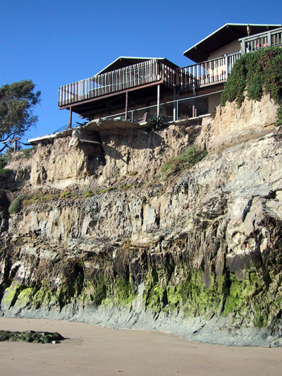
January 2002. Much of the support for balcony in front of the house on the left has been removed by erosion of the upper sandy part of the cliff. Photographed and copyright© by A. G. Sylvester, Jan. 2002 |
Previous Image | Back to Main Page | Cliff Retreat Rates