The material in this narrative is edited and transcribed from a summary report by Harold G. Arthur, Director of Design and Construction, U.S. Bureau of Reclamation. Reference: Arthur, H. G., 1977. Teton Dam Failure, pp. 61-71, in The Evaluation of Dam Safety (Engineering Foundation Conference Proceedings, Asilomar, Nov. 28 - Dec. 3, 1976), American Society of Civil Engineers, New York, 523 p.
USBR account of the dam failure | Mrs. Olson's slides |
Steven N. Ward's computer simulation of the dam failure
Overview of the Failure of Teton Dam, 5 June 1976
Teton Dam, a 305-foot high earthfill dam across the Teton River in Madison County, southeast Idaho, failed completely and released the contents of its reservoir at 11:57 AM on June 5, 1976. Failure was initiated by a large leak near the right (northwest) abutment of the dam, about 130 feet below the crest. The dam, designed by the U.S. Bureau of Reclamation, failed just as it was being completed and filled for the first time.
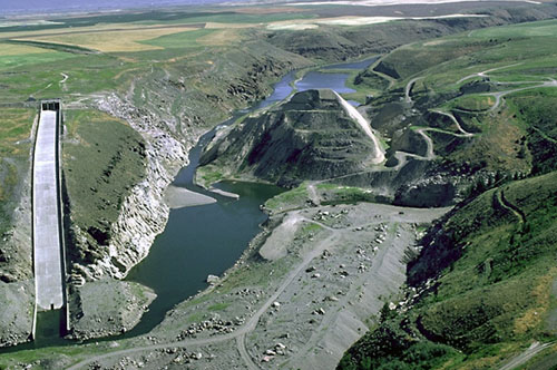 |
| Oblique aerial view northeast and upstream of Teton Dam site as it looks today. The right (northwest) abutment is between the spillway and the present course of the river. All that remains of the original dam is the terraced, pyramid shaped monolith in the center of the canyon in the center of the photograph. The cut on the right was made after the failure to determine the structure of the embankment. Photo by U.S. Bureau of Reclamation. |
Eyewitnesses noticed the first major leak between 7:30 and 8:AM, June 5, although two days earlier engineers at the dam observed small springs in the right abutment downstream from the toe of the dam. The main leak was flowing about 20-30 cfs from rock in the right abutment near the toe of the dam and above the abutment-embankment contact. The flow increased to 40-50 cfs by 9 AM. At about the same time, 2 cfs seepage issued from the rock in the right abutment, approximately 130 feet below the crest of the dam at the abutment-embankment contact.
Between 9:30 and 10 AM, a wet spot developed on the downstream face of the dam, 15 to 20 feet out from the right abutment at about the same elevation as the seepage coming from the right abutment rock. This wet spot developed rapidly into seepage, and material soon began to slough, and erosion proceeded back into the dam embankment. The water quantity increased continually as the hole grew. Efforts to fill the increasing hole in the embankment were futile during the following 2 to 2 1/2 hour period until failure. The sheriff of Fremont County (St. Anthony, Idaho) said that his office was officially warned of the pending collapse of the dam at 10:43 AM on June 5. The sheriff of Madison County, Rexburg, Idaho, was not notified until 10:50 AM on June 5. He said that he did not immediately accept the warning as valid but concluded that while the matter was not too serious, he should begin telephoning people he knew who lived in the potential flood path.
The dam breached at 11:57 AM when the crest of the embankment fell into the enlarging hole and a wall of water surged through the opening. By 8 PM the flow of water through the breach had nearly stabilized. Downstream the channel was filled at least to a depth of 30 feet for a long distance. About 40 percent of the dam embankment was lost, and the powerhouse and warehouse structure were submerged completely in debris.
Geology of the Teton Dam Site
Teton Dam is located in the eastern Snake River Plain, a broad tectonic depression underlain by rhyolitic and basaltic, late-Cenozoic volcanic rocks. The dam is in the steep-walled canyon that the Teton River cut into a relatively smooth to gently undulating, silt-covered, volcanic upland near the east margin of the plain. The river flows southwestward at the damsite.
The volcanic rock at the dam site consists of hard, welded, rhyolitic ash-flow tuff dated at 1.9 million years. Along the axis of the dam, the tuff ranges in thickness from about 50 feet in the left side of the channel section to more than 500 feet under the right abutment. The tuff is underlain by sedimentary rocks which are not exposed along the dam axis but were encountered in exploratory drill holes. On the left side of the canyon bottom, an erosional remnant of an intracanyon basalt flow overlies the tuff. On the right side of the canyon, the basalt and tuff are overlain by a thick accumulation of young alluvium. A thin layer of older alluvium is also intercalated between the tuff and the basalt.
The tuff in the right abutment is foliated and strongly jointed. The joints consist of both high-angle and low angle joints. The dominant high-angle joints are spaced from a few feet to about 10 feet apart, whereas the low-angle joints are generally widely spaced except in the upper 70 to 100 feet of the abutment. There the closer spacing results in a platy structure. After the dam failure, some of the joints were observed to be tight, others open as much as 5 inches. Some joints are lined with calcite, others are filled with silt and rubble.
Post failure reconnaissance revealed two low-angle discontinuities that were especially evident in the rocks of the right abutment. The upper discontinuity is the transition tetween the platy joint structure and underlying, more massive rock. The lower discontinuity, as evinced in the upstream part of the right abutment, is a flat-lying open fissure partially filled with rubble and calcite deposits. The orientations of both foliation and joints differ above and below the discontinuities.
The Teton Dam Project
Teton Dam was designed as a multi-purpose facility that would provide irrigation water, flood protection, electrical power, and water-based recreation. It was built across a deep canyon on the Teton River in the watershed of the Snake River about 12 miles northeast of Rexburg in southeastern Idaho. The dam rose approximately 305 feet above the stream bed and was about 3200 feet long at its crest. The reservoir behind the dam was 17 miles long with 200,00 acre feet of active capacity and 270,780 feet of inactive acre feet capacity, and 470 acre feet of dead storage, for a total capacity of 288,250 acre feet.
The siting of Teton Dam was the result of several studies. The first active investigation was conducted in 1932 at a site 15 miles upstream and due east of the site where the dam was finally constructed. The 1932 site was discussed by the U.S. Geological Survey in "Water Supply Paper 657" dated 1935. In 1946 the Bureau of Reclamation investigated two sites on Canyon Creek, a tributary to the lower Teton River. A March 1947 report showed that these sites were not economical and that seepage looses from the reservoir could be expected. The Corps of Engineers selected the eventual site for investigation at the location of Teton Dam and drilled two holes in July, 1957. The quality of rock encountered by this drilling was considered to be structurally adequate for a dam. It was recognized that seepage from the reservoir would occur. Further studies were made to determine the impact of seepage on the economics of the site.
The Bureau of Reclamation prepared a reconnaissance type report for Teton Dam in January 1961 and started core drilling at the site in July 1961. By March 1962 a report from the Corps of Engineers recommended construction of the Teton Project, including Teton Dam.
The Report of Findings on the Failure of Teton Dam, p. 6, reports that " . . . In reviewing the siting progress for Teton Dam, it is apparent that acquisition of geologic information of the dam site and reservoir was given high priority. A number of the reports was prepared by geologists. It was recognized early that the reservoir rim could transmit water in large quantities and that seepage from the reservoir could occur. Geologic conditions at all the sites studied were found to be comparable, as were reservoir seepage conditions. The sites differed primarily in their effects on the features to be included in the project."
Construction of Teton Dam
Some 10 million cubic yards of selected earth materials "dug mainly from the bed of the reservoir area" were used to build the multilayered structures of the dam, which was constructed in the period from February 1972 to June 1976. The center of the dam was a mixture of clay, silt, sand, gravel, and cobbles tightly compacted by tamping rollers to form a core that the Bureau of Reclamation engineers considered impervious to water. This was overlain by four additional layers of rock materials of various kinds.
The dam collapsed on 5 June 1976 just as water behind it was approaching full reservoir capacity for the first time. Whereas employees at the dam were called to work early Saturday morning, June 5, at approximately 8:30, and in spite of the fact that two days earlier engineers at the dam observed small springs in the right abutment downstream from the toe of the dam, nevertheless, the dam collapsed completely at 11:57 AM. At the time of failure, the reservoir was almost completely full, containing 251,000 acre feet of water. The major part of the reservoir emptied in about 5 hours after the first observation of embankment seepage.
Large open fissures were encountered during excavation of the key trench near the right end of the dam, about 700 feet from the canyon wall. The two largest, near-vertical fissures trend generally E-W and extend more than 100 feet below the bottom of the key trench. Some of the fissures are lined by calcite, and rubble fills some fissures. Several voids, as much as 6 inches wide, were encountered 60-85 feet below the ground surface beyond the right end of the dam and grout curtain.
Landslides or other evidence of instability were not found by geologic mapping and explorations of the right abutment before and during construction. Approximately 150,000 cubic yards of rock were stripped from the right abutment during failure, evidently by erosion by the escaping reservoir water and by seepage forces from bank storage return flow.
The Teton River loses water to the ground in the reach of the canyon where the dam is located. In the vicinity of the dam site, the regional water table slopes to the southwest, but at the dam site, it slopes 5/1/2 feet per mile to the northwest. In addition to the regional water table, a well-defined perched water table was 100 feet or more above the regional water table before the reservoir was filled. The perched water table sloped northward at the dam site, so ground water in the left abutment was near or a few feet above river level, and the ground water in the right abutment was near or a few feet below river level.
Large water losses occurred during drilling of exploratory core holes, and drilling fluid did not return to the surface. These water losses indicated that the joints and fissures were sufficiently open to receive and retain the cuttings produced by the drilling operations. Water losses and permeability tests showed that the rock from the rim of the canyon down to about 250 feet was much more permeable than the rock below this point. Geologists' logs of the drill holes record nearly 100 percent core recovery, but TV camera surveys of these same borings revealed many open cracks, mostly 0.1 to 0.5 inches wide - the maximum 1.7 inches wide). The high permeability was also confirmed by long term pump-in tests at rates of 165 to 460 gallons per minute.
Faults and Earthquakes
The level of seismicity is very low in the eastern Snake River Plain, and active faults are not known at or near the dam site. Regionally, faults tend to be roughly parallel and perpendicular to the northeast trend of the east Snake River Plain. Well-defined, northwest-striking faults have been mapped cutting volcanic rocks no closer to the dam site than 8 miles to the east and 10 miles to the southwest. Well-defined northeast-striking faults have been mapped no closer to the dam site than 7 miles to the ENE and 10 miles to the south. Some approximately located faults are 3-4 miles to the NNE.
U.S. Geological Survey geologists inferred the presence of a concealed, northeast-striking fault extending about 16 miles from the vicinity of Rexburg to about 500 feet west of the dam site. This inferred fault is not exposed in Teton River canyon or in the dam site excavations.
No seismic events larger than M 2.2 were recorded within 18 miles of the dam site during 2 years of operation of a seismic monitoring network before dam failure, nor was seismic activity recorded during filling of the dam. Failure of the dam cannot be attributed to seismic activity. The monitoring network did record the ground motion generated by the failure of the dam and release of the reservoir water for at least four hours on June 5, 1976.
Dam Design and Construction
Teton Dam was designed as a zoned earthfill embankment with a maximum height of 305 feet above riverbed. It would have created a reservoir of 288,250 acre-feet when filled to the top of the joint use pool. The spillway is a gated chute structure located at the right abutment. Low-level reservoir releases were to be controlled by a river outlet works in the left abutment and by an auxiliary outlet works in the right abutment, with maximum capacities of 3,300 cfs and 850 cfs, respectively.
The dam centerline was straight for 2,000 feet of its length and curved upstream on the right abutment for the last 700 feet. Upstream slopes were 2:5:1 above elevation 5185 and 3:5:1 below. Downstream slopes were 2:1 above elevation 5200 and 3:1 below. The crest width was 35 feet.
The embankment was composed of five specified zones. The center core, zone 1, is low-plastic to nonplastic silt compacted to obtain an average density of 98 percent of Bureau of Reclamation standard protocol at a moisture content averaging 1.5 percent dry of optimum. This material has a permeability of about 1 foot per year.
The core was overlain by zone 2, composed of sandy gravel compacted to an average relative density greater than 70 percent. Zone 2 was extended downstream across the floodplain and on the abutments underlying zone 3.
Zone 3, miscellaneous fill, was placed between zone 2 and the protective rockfill surface on the downstream side. In the design the engineering properties of zone 3 were assumed to be the same as zone 1. Zone 5 was rockfill in the outer parts of the embankment. Zone 4, compacted similarly to zone 2 or zone 3 depending on the nature of the material, served as the upstream cofferdam during stream diversion.
In the canyon bottom, a positive cutoff trench was excavated through the alluvium beneath the core and slightly upstream of the dam centerline. The cutoff trench extended through the alluvium to a depth of 100 feet to rock, with a minimum bottom width of 80 feet and 2:1 side slopes. Above elevation 5100, the cutoff was extended as a key trench into the rock to a minimum depth of 70 feet to reach groutable rock below the severely jointed rock. This key trench had a minimum design bottom width of 30 feet and 0:5:1 slopes.
Construction of Teton Dam began in February 1972. The river outlet tunnel was started in June 1972. During the tunnel construction, the river was diverted into a channel constructed along the right abutment. Also in 1972, excavation was in progress in the key trenches and in the spillway.
Diversion through the river outlet works occurred on June 8, 1973. During the 1973 construction season, the cutoff trench in the river channel was completed, as was the grouting in the lower part of the foundation. In October 1973 the first zone 1 material was placed in the bottom of the cutoff trench. On October 3, 1975, the river flow was diverted through the auxilliary outlet works to allow placement of second-stage concrete in the intake structure and gate chamber, installation of the outlet works gates, penstock manifold, outlet pipe, and other appurtenant metalwork and equipment. The dam was topped out in November 1975.
The dam foundation treatment, performed intermittently between November 1972 and July 1975, consisted basically of 70-foot-deep key trenches in both the right and left abutments above elevation 5100; a positive cutoff trench along the valley floor and in the abutments below elevation 5100, which had a minimum bottom width of 80 feet; a continuous grout curtain along the entire dam foundation; and a treatment of the rock surfaces under zone 1.
The entire embankment foundation was stripped of all unsuitable material including boulders, loose rock, and topsoil. At the zone 1-rock contact, the rock surface was cleaned using high pressure air and water jets. Open joints and cracks in the key trenches and cutoff trench bottom were treated by installing grout pipes and grouting through the pipes to refusal, and backfilling the voids at the surface with high slump concrete. Under zone 1, joints and cracks on the steep slopes of the key trenches and abutments which could not be readily treated from the natural surface were gravity filled with grout slurry or filled with specially compacted zone 1 material.
The grout curtain consists of three lines of grout holes except in certain reaches where there was more competent rock and where a single line of grout holes was used. In the multiple-curtain, the lines were spaced 10 feet apart. The central line was drilled through the 3-foot wide by 3- to 5-foot deep grout cap. Maximum depth of holes in all three lines was 260 feet with the exception of the spillway area where the holes were 310 feet deep. In addition to the curtain grouting, blanket grouting was performed in selected areas. The total injected grout included 496,515 ft3 feet of cement, 82,364 ft3 of sand, 132,000 pounds of bentonite, and 418,000 pounds of calcium chloride into 118,179 lineal feet of drilled holes.
Reservoir Filling
On March 1, 1976, the reservoir water surface was at elevation 5164.7 and the auxiliary outlet works was discharging 295 cfs. The reservoir water surface was rising at approximately 0.2 foot per day. On March 23 the allowable filling rate was increased from 1 to 2 feet per day because: 1) the river outlet works was not yet completed, 2) the runoff from the Teton River was abnormally high, 3) there were no apparent abnormal increases in the ground water observation wells, 4) an examination of the earthwork control records showed that the embankment had been placed as specified, 5) no available evidence indicated that the foundation treatment was unsuccessful, and 6) there was a desire to fill the reservoir for irrigation use in 1976.
Because of the work being done in the river outlet works tunnel, the reservoir was permitted to fill without opening the works. This decision was based on the absence of reported evidence of embankment or structural problems, and because the spillway was operational and would have sufficient capacity to accommodate any flood.
From May 11 until June 5 the average rate of rise was 3.0 feet per day with a maximum of 4.3 feet on May 18.
Dam Failure
Prior to June 5, no seepage conditions of any type were noted upstream or on the downstream face of the dam. On June 3, two small spring areas developed on the right abutment approximately 600 and 900 feet downstream from the spillway stilling basin and just about river level. They were flowing clear water at approximately 40 and 60 gallons per minute.
On June 4, another small spring was found approximately 150 feet downstream from the toe of the dam on the right abutment, flowing clear water at approximately 20 gallons per minute. The abutments and downstream face of the dam were examined during the day until dark, and no seepage conditions were reported on any part of the embankment.
After the major leaks were discovered on the morning of June 5, efforts were initiated to channel the flow so it would not enter the powerhouse. At this time, safety of the dam was not believed in jeopardy, however, a wet spot on the downstream face began eroding its way into the embankment. Two dozers began pushing rock material into the hole on the downstream face of the dam. At 10:30 AM the larger of the two dozers began to slide into the hole.
At 11 AM a whirlpool was observed in the reservoir 10 to 15 feet from the intersection of the reservoir surface with the embankment, and 100 to 150 feet from the right shoreline. The whirlpool gradually increased in diameter and depth but stayed in a fixed location. Two dozers began to push riprap into the whirlpool.
At 11:30 AM both dozers on the downstream edge of the embankment were lost in the eroded embankment hole. The embankment was now eroding rapidly. The erosion path in the embankment followed the right abutment upstream along the contact until it was approximately in line with the whirlpool.
The crest of the embankment fell into the water at 11:55 AM, and the dam was breached at 11:57 AM. The first observed embankment seepages had occurred only 2 to 2-1/2 hours earlier.
At the time of failure, the reservoir was almost full and contained 251,000 acre-feet of water. After the breach the main part of the reservoir emptied in about 5 hours.
Aftermath
Investigations by commissions and boards together with recriminations, typical of most disasters, followed the failure of Teton Dam. Lessons were learned, but no attempt has been made to rebuild the dam. Its remnant sits today in silent testimony that "Nature bats last."