Seismic Search for Magma Chambers Beneath Jan Mayen and Field Inspection of the 1970 Beerenberg Eruption Area
by
Arthur Gibbs Sylvester
Department of Earth Science, University of California, Santa Barbara, CA 93106
Introduction
A major volcanic eruption occurred on Jan Mayen in 1970 simultaneously with, or within a few hours after a series of moderately strong offshore earthquakes (Gjelsvik, 1970; Siggerud, 1971; 1972; Sylvester, 1972; 1974). Historic eruptions also occurred in 1732 (Anderson, 1746), 1818 (Scoresby, 1820), and 1985 (Imsland, 1986). Geomorphic evidence of recent volcanic activity is abundant all over the island; local earthquake activity is common.
The 1970 eruption was so unexpected and impressive and appeared to constitute
such an immediate threat to the important weather and navigation station
only 30 km from the eruption site that station personnel were abruptly
evacuated to the Norwegian mainland. The evacuation was a costly and unnecessary
endeavor as it turned out, but it dramatically pointed out a serious and
previously unrecognized hazard to the continued operation of the station.
Alternatives to total evacuation were clearly needed in the event of future
eruptions, because the island is commonly ice-bound, preventing easy evacuation
by ship, and frequent storms and fog obviate evacuation by aircraft at
any given time.
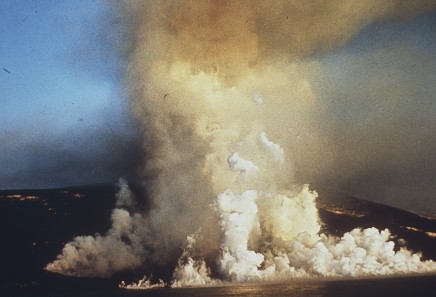
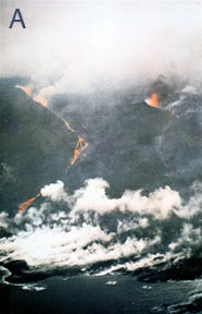
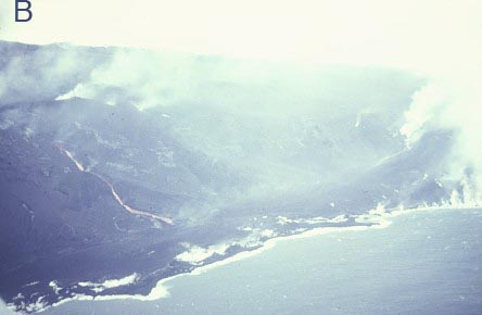
Fig. 1. View toward northwest of steam and eruption clouds from aircraft located a few kilometers offshore of the 1970 eruption. Photographed by T. Siggerud (1971)
Surveillance initiatives were developed together with new emergency contingency
plans. Thus, geophysical equipment was installed to monitor earthquake
and crustal deformation presaging impending eruptions (Havskov and Atakan,
1991). One of the studies undertaken shortly after the 1970 eruption was
to search for magma bodies beneath Jan Mayen (Sørnes and Navrestad,
1975). This web site presents an overview of a research excursion in August
1973 to search for magma chambers beneath Jan Mayen and to inspect the
1970 eruption site, 21 months after the eruption ceased.
Geography, Geology, and Tectonic Setting
Jan Mayen is a small, isolated, volcanic island located about 600 km north of Iceland and about 500 km east of Scoresby Sound in East Greenland. It is 54 km long with an areal extent of about 380 km2. Its tectonic position is on or very near the junction of the southern end of the Mohns Ridge and the central part of the Jan Mayen fracture zone (Sylvester, 1975; Havskov and Atakan, 1991). Jan Mayen is generally regarded as a ridge of Paleozoic or Precambrian crust about 15 km thick that was chipped off Greenland in late Paleocene/early Eocene time (Talwani and Elholm, 1977; Bott, 1985; Skogseid and Eldholm, 1987; Larsen, 1988).
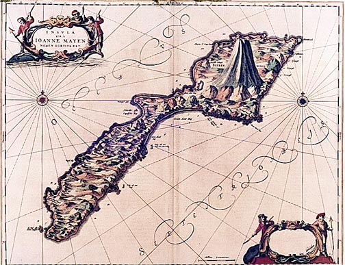
Fig. 1. Antique map of unknown vintage and origin clearly depicting the dominance of Beernberg over the rest of the island of Jan Mayen
Fig. 2. Arctic explorer William Scoresby's map of Jan Mayen, 1820
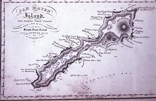
The island comprises two parts, Nord Jan and Sør Jan, which are
joined by a low isthmus (Figs. 1, 2). Nord Jan is dominated by the northernmost
active subaerial volcano on the planet, Beerenberg,
a most impressive, major shield volcano about 25 km in diameter at sea
level with a nearly symmetrical summit lava cone reaching an elevation
of 2277 m (7470 ft) above sea level. It is a snow
bedecked peak with many glaciers that radiate from a central volcanic
crater at the summit. Some of the glaciers
reach the sea. Ankaramite and Mg-rich basalt typifies Nord Jan and Beerenberg.
Sør Jan is a narrow volcanic tableland, nearly 500 m high, built
of repeated fissue-controlled eruptions consisting of more evolved basalt,
including tristanite and trachyte. The oldest exposed lavas on Jan Mayen
are regarded as being younger than 0.7 my, whereas abundant domes, cinder
cones, and lava flows are recent to historic (Fitch et al., 1965)..
Second Excursion
I have made two trips to Jan Mayen – the first
in February 1973 to assess possible initiatives to monitor volcanic
activity on the island through the use of seismology and geodesy. The
second trip was August 1973 to participate
in a seismic search for magma beneath the island, and to inspect the 1970
eruption site (Sylvester, 1974).
The seismic survey expedition set out from Harstad, northern Norway, on
the naval frigate KNM Trondheim
into what the Norwegian navy designated as a "small storm".
It was small enough to send only half of the crew and me below decks for
three days with acute seasickness, and for its waves to break windows
in the forward cannon of the frigate that is built for speed, not stability,
in rough seas.
Jan Mayen weather is normally foul 362 days of the year, but we were extremely
fortunate to be at Jan Mayen during the other three days of calm, clear,
almost balmy weather after such a bad storm. We had smooth sailing for
the seismic study and fine weather for a hike into the 1970 eruption area
at the north end of the island. The research plan was to establish three
single-component seismometers at several
recording sites on land together with a long string of event recorders
perpendicular to the length of the island, and then have frigates KNM
Trondheim and KNM Stavanger drop depth
charges at pre-determined intervals around the island (Fig. 3). The
explosions would generate S waves, which do not pass through fluids, such
as magma, then subsequent triangulation of explosions and reception and
non-reception of S-waves would map magma bodies beneath the island.
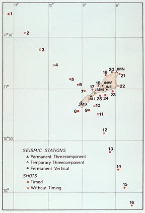
Fig. 3. Location of seismographs on Jan Mayen and subsea shot locations for seismic survey to search for magma chambers beneath Jan Mayen.
The results of the seismic survey were rather inconclusive, owning to
a major recording error during the shooting program, but it was possible
to conclude permissively that three small magma chambers exist beneath
the island – one each beneath the south, central, and north parts
of the island, consistent with the places of most-recent appearing lava
flows and cinder cones (Sørnes and Navrestad, 1975).
Hike into the 1970 Eruption Area, 16 August 1973
I accompanied a small seismograph crew that made camp
at Nordbukta at the north end of Jan Mayen. While the seismic survey
was in progress and the technician tended the seismograph and ancillary
equipment, C.A. Gløersen and I hiked to the 1970 eruption area
to observe the products and results of the 1970 eruption (Fig. 4, 5).
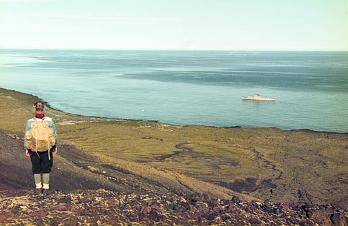
Fig. 4. View from the 1970 eruption area across the lava plain created in that eruption to the KNM Trondheim during the seismic survey. Photograph by Sylvester, 16 August 1973.
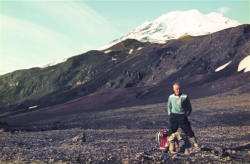
Fig. 5. View of Siggurdbre and Skrukkelia vents on the flank of Beerenberg. Dark red-brown lava flows cascaded down the steep, 500 m high cliff, and then flowed out across the coastal plain. From this vantage point, we hiked up to the two vents to obtain a closer look at the results of the eruption. Photograph by Sylvester, 16 August 1973.
From contemporary photographs and reports of the eruption, from subsequent
aerial photographs, and from what we could see on the ground three years
afterward, a fissure eruption coalesced into four main vents distributed
along a NE-trending, 6 km-long fissure, which is about 600 m above sea
level at its southwest end and nearly sea level at its northeast end (Fig.
6).
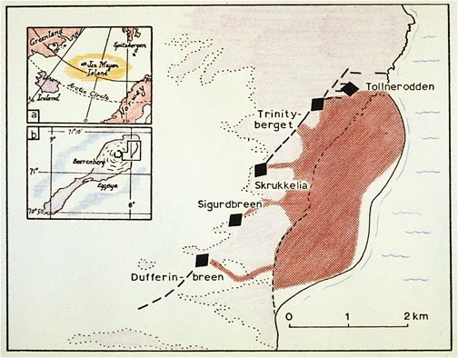
Fig. 6. Map of 1970 eruption site with locations of main vents (black triangles), principal fissures (black dashed lines), new lava field (red), old lava (pink), snow and ice (white), and sea (blue wrinkle lines). Inset A depicts the location of Jan Mayen relative to Greenland, Svalbard, Norway, and Iceland. Inset B depicts Jan Mayen with the location of the main map. From Sylvester (1974).
Fig. 7. A. Sigurdbre lava flow on the left with Skrukkelia vent erupting on the right. B. Aerial view west of lava stream in left side of image is from Dufferinbre vent. Photographs by T. Siggerud (1971).
The lava streamed down steep, narrow canyons to the sea (Fig. 7) where
the flows changed abruptly from pahoehoe flows into aa flows.At the base
of the canyons, the lava flows coalesced to form a delta-shaped lava plain
with a subaerial extent 4 km long and 1 km wide before it was partially
eroded by strong waves and drift-ice (Fig. 8). The estimated volume of
the erupted lavas is 0.5 km3.
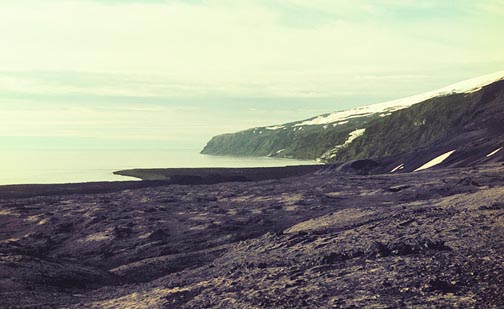
Fig. 8. Ground view of the lava flows from Siggurdbre vent and, in the middle distance, the delta-shaped lava plain formed from basalt flows from Dufferinbre vent. The vantage point is about half way to Siggurdbre vent from the lava plain in Fig. 4. Photograph by Sylvester, 16 August 1973..
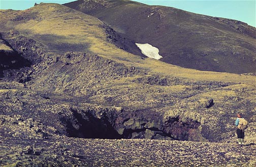
Fig. 9. Collapsed roof of lava tube from one of the main vents along the 1970 eruption fissure on the skyline. Photograph by Sylvester, 16 August 1973.
We climbed up to Skrukkelia and Siggurdbre vents over considerable tephra
and lava, and we passed several collapsed
lava tubes large enough to drive a bus through (Fig. 9). We encountered
much hydrothermally altered tephra,
some of which was still steaming. From Skrukkelia, we could look down
on the new lava plain (Fig.8) and see that the surface of the plain was
rumpled into wave-like sequence of ridges and troughs, wave ogives, that
were convex outward from the coast. I estimate their wave length was about
15-20 meters and amplitude about 4-5 m. Regrettably we were unable to
obtain a good photograph of them.
Upon our return to Nordbukta camp, another fellow and I jumped into the
sea – and jumped right out. Seawater temperature was 3° C (37°
F). I learned much later that the east half of Nordbukta and probably
our camp was overrun by lavas from the 1985 eruption (Imsland, 1986).
Go to Volcanoes.com
Cited References
Anderson, J., 1746. Nachrichten von Island, Grönland und der Strasse Davis. Hamburg.
Bott, M.H.P., 1985. Plate tectonic evolution of Icelandic Transverse Ridge and adjacent regions. Journal of Geophysical Research 90, 9953-9960.
Havskov, J., and K. Atakan, 1991. Seismicity and volcanism of Jan Mayen. Terra Nova 3, 517-526.
Imsland, P., 1986. The volcanic eruption on Jan Mayen, January 1985: Interaction between a volcanic island and a fracture zone. Journal of Volcanology and Geothermal Research 28, 45-53.
Johansen, S., 1982. The origin and age of driftwood on Jan Mayen. Polar Research 17 (2), 125-146.
Larsen, H.C., 1988. A multiple and propagating rift model for the NE Atlantic, in Early Tertiary Volcanism and Opening of the NE Atlantic, edited by A.C. Morton and L.M. Parson, Geological Society of London Special Publication 39, 157-158.
Scoresby, W., 1820. Account of the Arctic Regions. 1, p. 154-169, Edinburgh.
Siggerud, T., 1971. Vulkanutbruddet på Jan Mayen høsten 1970. Naturen 451-473.
Siggerud, T., 1972. The volcanic eruption on Jan Mayen 1970. Norsk Polarinstitut Årbok for 1970, 5-18.
Sylvester, A.G., 1974. Surface faulting and fumerolic activity since the 1970 Beerenberg eruption, Jan Mayen. Norsk Geologisk Tidsskrift 54 (4), 385-393.
Sylvester, A.G., 1975. History and surveillance of volcanic activity on Jan Mayen Island. Bulletin ofVolcanology 39-2, 1-23.
Skogseid, J., and O. Eldholm, 1987. Early Cenozoic crust at the Norwegian continental margin and the conjugate Jan Mayen Ridge. Journal of Geophysical Research 92, 11471-11491.
Sørnes, A., and T. Navrestad, 1975. Seismic survey of Jan Mayen. Norsk Polarinstitut Årbok for 1973.
Talwani, M., and O. Eldholm, 1977. Evolution of the Norwegian-Greenland Sea. Geological Society of America Bulletin 88, 969-999.